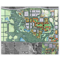
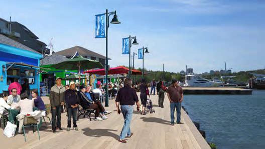
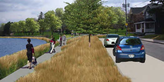
Barrie Waterfront & Marina Strategic Plan, City of Barrie
The Planning Partnership, Plan B Natural Heritage and Baird
+ Associates are preparing a Waterfront and Marina Strategic
Plan for the City of Barrie. The Strategic Plan is based on
a framework to protect and enhance natural features, to
establish a hierarchy of activity centers (parks, marina, boat
launches) across the waterfront, to implement a connected
system of trails for walking and cycling and to establish a
series of landmarks, beacons and kiosks to focus attention
and activity on the waterfront. Detailed recommendations
are included for the North, Central and South shores of the
waterfront. The Strategic Plan also sets the framework for
continued intensification along the waterfront to ensure the
area is a focus for residential and mixed use development.
The Plan has also analyzed several options for expanding the
marina. The Planning Partnership has subsequently prepared
more detailed concept plans for four key waterfront parks.
Photo Gallery:
^ back to top
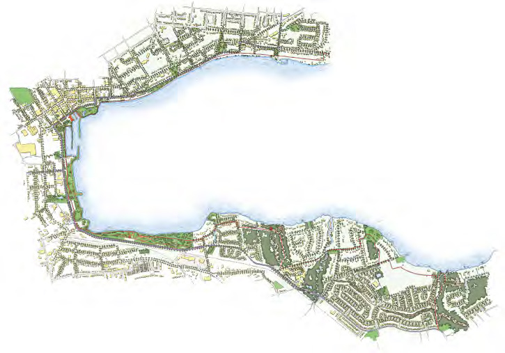
Brantford Waterfront Master Plan, City of Brantford
The Planning Partnership with Plan B Natural Heritage, Baird
& Associates and TCI Management Consultants completed
the CSLA Award winning Waterfront Master Plan for the City
of Brantford. The year-long work program was organized
around four consultation events that included a summit,
two community workshops and an open house. There was
a history of discontent among some residents and interest
groups with the City. The public forums were very carefully
designed to ensure productive input to the design team.
The Master Plan is framed within an in depth understanding
of natural features along 35 km of the Grand River, and
the diversity and richness of evidence of 11,000 years of
settlement history. It is the compilation of input received
from carefully listening to all of the stakeholders that was
used to shape the defining principles and initiatives for 6
layers of the Plan: environment, parks, access, heritage and
culture, destinations and neighbourhoods and districts. The
complexity of issues were resolved to result in dozens of
recommendations that are mutually supportive and
complementary to each other.
The Brantford Waterfront Master Plan guides decisions
with respect to lands along the Grand River, designated a
Canadian Heritage River, within the urban boundaries of
the City. The Plan enables Brantford to strategize for growth
that is distinctly sensitive to restoring natural systems and
protecting a rich tapestry of heritage and cultural resources.
The Waterfront Master Plan was unanimously adopted by
Council and broadly endorsed by the community
Photo Gallery:
^ back to top
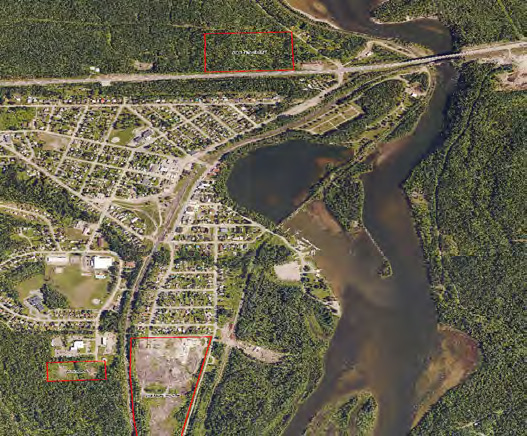
Nipigon Waterfront Development Master Plan
The Planning Partnership is currently working on a Waterfront Development Master Plan, in association with PLAN B Natural Heritage and TCI Management Consultants. The Plan will assist the Township of Nipigon in acquiring opportunities to enhance tourism, encourage economic growth and expand access to natural amenities. The project is built around a comprehensive community engagement strategy that includes online surveys and an intensive 4-day public workshop to ensure the needs of the community are met. After input from the public, stakeholders and Township Staff has been incorporated, the resulting Plan will address the waterfront, downtown and marina by identifying appropriate waterfront development, trail connections, park improvements and enhancements for boat access.
Photo Gallery:
^ back to top
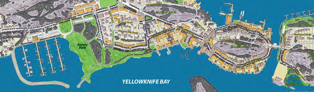
Yellowknife Harbour Plan
The Planning Partnership, Baird and Plan B Natural Heritage
have recently completed a plan for Yellowknifes Harbour. The
plan was developed through an extensive public engagement
strategy. The team conducted three major consultation
events where City staff, stakeholders, Yellowknifes Dene First
Nations, major landowners and residents were invited to
collaborate with the team. The harbour master plan sets out
6 frameworks with recommendations for natural features,
heritage and culture, trails, neighbourhoods, harbour uses
and parks. A sound implementation strategy addresses
harbour management, phasing, partnerships, capital and
operating costs.
Photo Gallery:
^ back to top
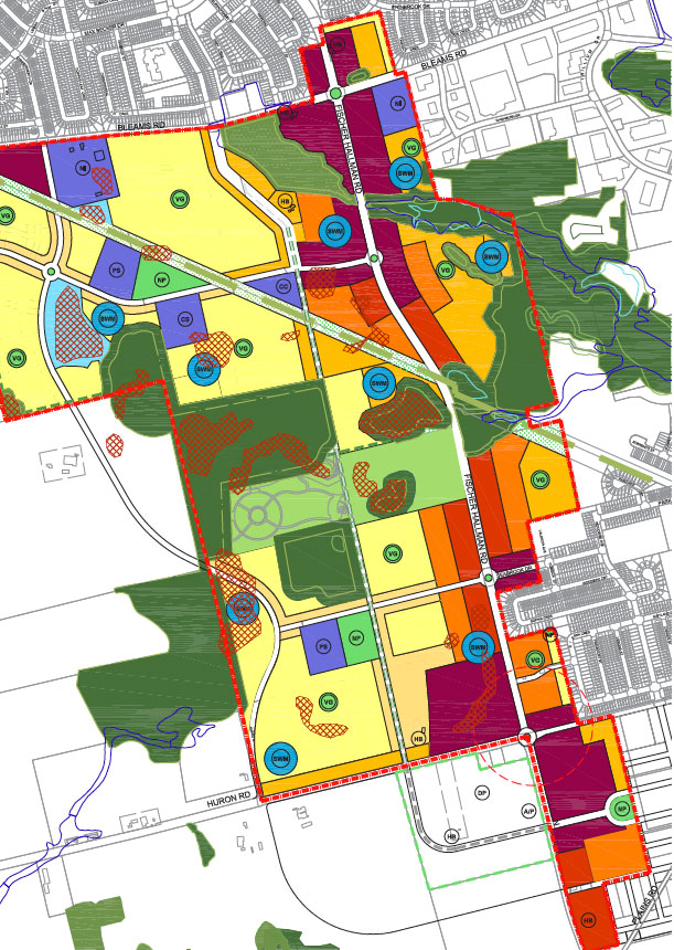
Southwest Kitchener Master Plan, City of Kitchener
The Planning Partnership, together with SCS
Consulting, Poulos & Chung and PLAN B
Natural Heritage, was retained in 2010 by
the City of Kitchener to develop a Community
Master Plan for the largest remaining Greenfield
area (approximately 430 hectares) within the
urban boundary that is contemplated for urban
development. The Community Master Plan included
the preparation of a Transportation Network Study
and confirmation of requirements for infrastructure
and community facilities such as parks, recreational
uses, schools and cultural amenities. The preferred
Community Master Plan provided the basis for
a subsequent secondary plan with the overall
objective of delivering a complete community that is
planned, designed and developed to be walkable,
transit-supportive, and respectful of the natural
environment.
Photo Gallery:
^ back to top
The Sutton / Jackson's Point Secondary Plan, Town of Georgina
The Planning Partnership, together with SCS
Consulting, Poulos & Chung, and PLAN B Natural
Heritage, reviewed and updated the Sutton/
Jackons Point Secondary Plan. The refinements
to the plan included the addition of a specific
designation for Jacksons Point, recognizing its
unique character, development of new policies for
growth along main corridors while providing stability
to existing residential areas, and enhancement
of environmental policies. As a component of the
Towns Five-Year Official Plan Review process, The
Planning Partnership also prepared urban design
guidelines as a compendium appendix to the Plan. A
two-day workshop was employed at the initial stage
of the plan to provide a forum for public input into the
vision and basic principles that served as the basis
for the Secondary Plan policies.
Photo Gallery:
^ back to top
Kleinburg-Nashville Focus Area Study, City of Vaughan
The Planning Partnership recently led a team, which
included PLAN B Natural Heritage, to establish an
updated land use and urban design framework for the
Kleinburg-Nashville Community Plan. The objective of
the study was to ensure conformity and coordination
with Provincial, Regional and City plans and initiatives.
Important considerations for new development within
the area include the maintenance of it`s residential and
village character, and mitigating the impacts of traffic,
noise, and demand for community services. This study
also included the coordination of many parties working
together as well as an extensive public consultation
program.
Photo Gallery:
^ back to top
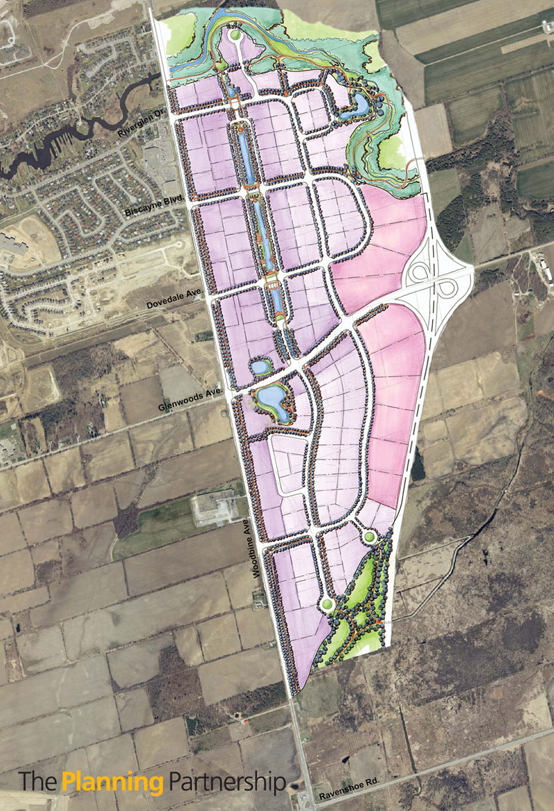
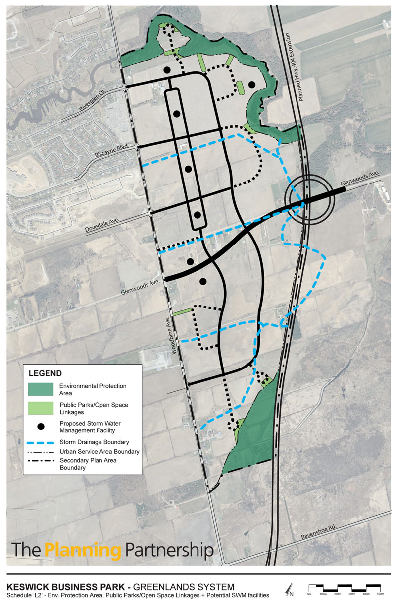
Keswick Business Park Study, Town of Georgina
A natural heritage inventory and constraints analysis was completed, as part of a Secondary Plan study for
the Keswick Business Park. A comprehensive inventory of vegetation (ELC, flora), wildlife and fisheries was conducted along the Maskinonge River corridor abutting the study area. A key component of the study was to establish a defensible environmental protection framework in accordance with the Natural Heritage policies of
the Provincial Policy Statement, the Greenbelt Plan and LSRCA Regulations. Several environmental enhancement/restoration opportunities were identified for the Maskinonge River corridor including removal of
in-stream barriers, restoration of disturbed floodplain/wetland habitat, and innovative stormwater/ground-
water management measures.
Photo Gallery:
^ back to top
SW Brantford Secondary Plan, City of Brantford
This study included a comprehensive inventory of the natural environment, including D’Aubigny Creek
(coldwater stream) and tributaries. The results of the natural heritage inventory were used to identify opportunities/constraints to future development, and to provide an open space “framework” for the
development
of a preferred land use plan and related policies. Restoration and enhancement opportunities for D’Aubigny
Creek, a tributary to the Grand River, were identified in the study.
Photo Gallery:
^ back to top
North Hespeler Community, City of Cambridge
Building on the findings of the Forbes Creek Subwatershed, a natural heritage protection and enhancement framework was established for a secondary plan in North Hespeler. Key elements of the study included
identifying appropriate locations for roads and services that would minimize impacts to the natural
environment. Guidelines for future environmental studies and monitoring requirements were also identified. An assessment of the potential impacts of servicing the study area and environmental monitoring requirements were also developed as part of separate Class Environmental Assessment.
Photo Gallery:
^ back to top
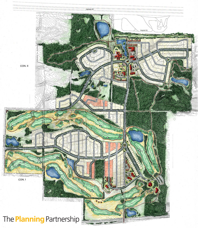
Tucker Creek Master Plan, Port Hope
A comprehensive inventory of environmental features was completed as part of a proposed residential/golf
course community situated on a large parcel of lands located south of the Highway 401 corridor. A key
component of the study was identifying opportunities and constraints to future development within the
headwaters of five watercourses, including coldwater tributaries. Protection of woodlots, wetlands, linkages
and riparian buffer zones provided a framework for the proposed development. Enhancement and restoration opportunities were also identified.
Photo Gallery:
^ back to top
Orchard Community Secondary Plan and Subwatershed Impact Study, City of Burlington
As part of Secondary Plan exercise a Subwatershed Impact Study was completed for a 275 ha study area located adjacent to the Bronte Creek Valley ESA. Key study elements included the inventory and functional evaluation
of terrestrial/aquatic habitat features, identification of an environmental framework for preparation of land use concept plans, and development of environmental management recommendations and implementation
guidelines for plans of subdivisions
Photo Gallery:
^ back to top
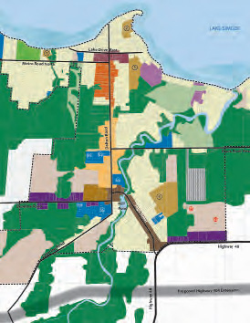
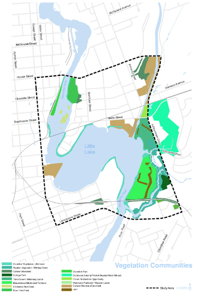
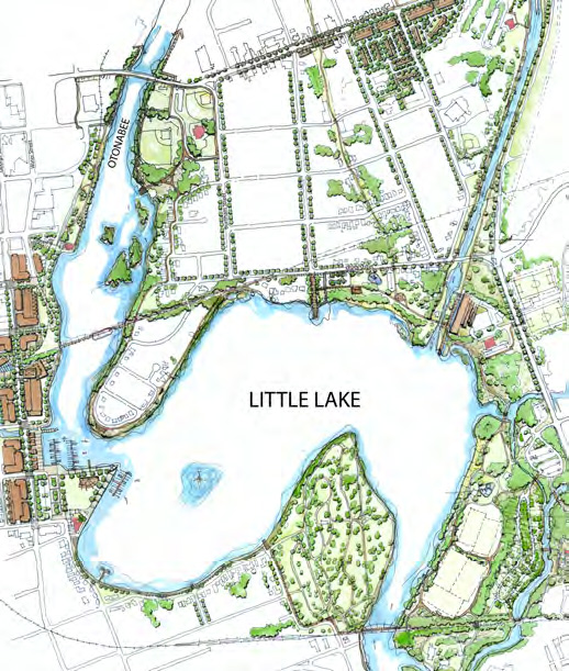
Little Lake Master Plan, City of Peterborough
The Planning Partnership led a multidisciplinary team, including Plan B Natural Heritage and Baird & Associates, in the completion of a waterfront master plan for Little Lake in downtown Peterborough. Downtown Peterborough, including its beautiful residential neighbourhoods, well used parks and locks of the waterway, provides the context for the master plan. The master plan evolved through an open and collaborative process with the community, who expressed strong commitment to protecting the resources of Little Lake, as well as enhancement to nine parks, a 7km trail, four gateways, eleven locations for boat access and two areas for intensification.
Photo Gallery:
^ back to top
Natural Heritage Inventory and Analysis – Lands North of Highway 5, Town of Oakville
The purpose of the study was to establish a defensible and implementable environmental protection framework
that would form the basis for subsequent Secondary Plan and Subwatershed level studies, and that would ensure environmentally sustainable urban development for a 4000 ha study area located north of Dundas Street. A comprehensive field inventory program, encompassing vegetation, forestry, wildlife and fisheries, determined
the ecological attributes, functions and linkages within the study area and the larger regional landscape setting. Based on the results of the surveys, the natural features were evaluated in the context of the Natural Heritage Section of the Provincial Policy Statement and were ranked in terms of their “significance” and priority for environmental protection. Areas suitable for integration into the urban fabric as well as areas that did not pose
a constraint to future development were also identified. Environmental management recommendations and mitigation strategies were developed to ensure environmentally sustainable urban growth. A key element of
the project was to review and select appropriate planning mechanisms and strategies for implementing the
Natural Heritage Framework.
Photo Gallery:
^ back to top
Bennie Farm Secondary Plan
Situated in Leamington, the Bennie Farm property posed some unique challenges given the presence of
isolated, mature Carolinian woodlots and the proximity to the Lake Erie shoreline. Through a combination of
an elongated stormwater management facility (greenway) and open space park uses, the woodlot features
were connected and buffered with compatible land uses. Traffic calming measures were introduced in key
locations to minimize impacts to wildlife movement. Nature trails were proposed within the woodlots to
provide residents with passive recreational opportunities.
Photo Gallery:
^ back to top
|